Quantcast
Channel: nyc subway – 6sqft
Viewing all 390 articles
Browse latest View live

POLL: Are You Happy With Governor Cuomo’s Planned Subway Changes?

$
0
0
new mta subway designs 2016 2

On Monday, as 6sqft reported, Governor Cuomo unveiled the MTA’s “plans to build 1,025 new subway cars, and to modernize 31 of the city’s more than 400 stations.” Most of the new fleet will be of the open-gangway format, and they’ll boast wider doors, Wi-fi, USB ports, better lighting, cell service, security cameras, full color digital information displays, and a new blue and gold color palette that represents New York’s state colors.

Since the upgrades are part of the $27 billion capital plan that was approved in May, some critics are questioning whether the changes are more cosmetic and brag-worthy, rather than functional. But the city explains that the design of the new cars will help alleviate overcrowding, thereby reducing delays. What do you think–can the MTA do better?

RELATED:


MTA Announces Details on L Train Shutdown To Begin in 2019

$
0
0
brooklyn_williamsburg_bedford_mta_joe_buglewicz

The MTA plans to announce today that the long-dreaded L train shutdown for repairs needed on the Canarsie tunnel that runs beneath the East River will commence in 2019 and take the line out of service from Manhattan to the Bedford Avenue station in Brooklyn for 18 months, as reported by the New York Times. The 18-month option was the expected choice, the alternative being a partial three-year shutdown that would give about one in five passengers service to Manhattan (20 percent of current service). The agency needs to do major repairs on damage done by the 2012 superstorm Sandy, and while the tunnel is “not in grave danger of collapse,” according to the MTA, it can’t go untreated. As 6sqft previously reported, night and weekend service is off the table because of the amount of work that needs to be done, and building a third tube would be time- and cost-prohibitive.

NYC subway commute

Amid fears of an impact on local businesses or a dip in real estate values along the L line, elected officials pushed for alternative travel options wherever possible. The MTA is considering beefing up service on the G, J and M lines, offering shuttle buses over the Williamsburg Bridge and adding more buses to the already existing route.

When the impending shutdown was first announced early this year, several community meetings on the topic revealed concerns over a lack of transparency from the MTA and fear of the impact the service interruption would have. Last January an MTA representative was asked to leave a Town Hall meeting on the subject by angry business owners and advocacy groups for not being able to provide enough information on when, and for how long, the north Brooklyn subway line would be out of commission.

The MTA anticipates that the reconstruction will be among the largest disruptions in the agency’s history. The shutdown will affect neighborhoods already strained under current public transportation options. According to MTA data, ridership has tripled since 1990. Currently, over 225,000 riders travel from Brooklyn to Manhattan daily, and an additional 50,000 use the L to travel within Manhattan.

New York City Transit (the agency that runs the city’s subways and buses, part of the MTA) president Veronique Hakim said officials hope the repairs will get done as quickly as possible for the least possible impact on riders. “It really came down to our wanting to pick an option that minimized inconvenience to the customer,” Ms. Hakim said Friday in an interview. “This is the, ‘Get in, get done, get out,’ option.”

[Via NYTimes]

RELATED:

MTA Likely to Implement Fare Hike to $3 by 2017

$
0
0
metro card nyc

Start saving your quarters; the MTA all but definitively announced at its board meeting yesterday that it will raise subway and bus fares by 2017 in an effort to raise more than $300 million annually. This is part of their four-year financial plan that includes fare and toll hikes every two years to

Jamison Dague of the nonprofit Citizens Budget Commission told the Daily News that if past increases are any indication, the MTA will likely raise fares from $2.75 to $3, a four percent increase that would bring in roughly $308 million through 2020. And if another increase was implemented in 2019, the cash-strapped agency would pull in an additional $594 million over two years.

This is the agency’s fifth fare hike since 2009. The last increase came just this past March, when rides went up from $2.50 to $2.75. And a month later, in April, top transit officials warned that if the MTA wasn’t able to bridge its $15 billion budget gap, fares could’ve been raised to $3.15. But this was before the state and city finally reached an agreement to keep the MTA’s $26.1 billion, five-year capital plan on track, which will partly fund Governor Cuomo’s recently unveiled high-tech subway cars and stations.

According to the Daily News, “In 2015, the MTA pulled in $7.7 billion in fare and toll revenue, which covers half of what it costs the MTA to run its system.” And this past year saw a record-breaking annual ridership of 1.7 billion, the highest since 1948.

The MTA noted that the hikes are part of a budget projection and could change when the numbers are reevaluated in November. A final vote is planned for December.

[Via NY1 and NYDN]

RELATED:

New Interactive Subway Game Lets You Build the Transit System of Your Dreams

$
0
0
Brand New subway, subway map, robert moses, jason wright, maps, interactive games, urban planning, transit system, mta

A new interactive New York City subway planning game created by electrical engineer Jason Wright gives you a chance to try your hand at building the subway system of your dreams. Though based on a similar idea to Dinosaur Polo Club’s Mini Metro, the game goes further and gives players a lot more to work with. “Brand New Subway” lets players start from scratch or use current subway maps, modify historic maps dating as far back as the 1900s or use maps from the future (like the planned 2025 subway system map pictured above) (h/t DNAinfo).

v

Wright created the game as a submission to “The Power Broker” game design competition, a challenge to turn a seminal work of urban design literature into a game–in this case, to transform Robert Caro’s 1974 Robert Moses biography into “playable, interactive form that preserves the flavor and themes of the written work.” Submissions could be in the the form of a digital or tabletop game.

The completely addictive game is built on a real map of New York City and draws from a variety of data sources (census data, jobs data, existing transportation demand data, etc.). When players build stations the data is used to calculate factors like daily ridership at each station and even to estimate things like single-ride MetroCard fare based on the costs of construction and maintenance. Ridership and fare are combined to inform a letter grade which is based on the actual daily ridership of today’s subway (the current system gets a B).

Brand New Subway Reroute L 2
One solution to the L Train tunnel conundrum.

Brand New subway, subway map, robert moses, jason wright, maps, interactive games, urban planning, transit system, mta
The F really needs to do a better job in the East Village.

Players can use the game to address real problems of affordability and lack of reach, or build a total fantasy transit system that, for example, only runs between home and the office with a stop at the grocery store.

While Moses was known to favor highways over public transportation, the designer believes the game embodies the idea of autonomy and the controversial planner’s utter disregard for political oversight. In the “Sim City”-like game, the player “acts as designer, engineer, and omnipotent governor all in one” with later versions even allowing players to add “natural disasters.”

Wright says the game is targeted at people who actually ride the subway and feel they have an investment in what they’re designing, encouraging players to put on their Robert Moses hats and “improve on transportation in their own neighborhoods and in ways to which they have a personal connection.”

[Via DNAinfo]

RELATED:

v Brand New subway, subway map, robert moses, jason wright, maps, interactive games, urban planning, transit system, mta Brand New subway, subway map, robert moses, jason wright, maps, interactive games, urban planning, transit system, mta Brand New subway, subway map, robert moses, jason wright, maps, interactive games, urban planning, transit system, mta Brand New subway, subway map, robert moses, jason wright, maps, interactive games, urban planning, transit system, mta Brand New subway, subway map, robert moses, jason wright, maps, interactive games, urban planning, transit system, mta

Mapping Subways, Buses, and Free Transfers in One Place

$
0
0
BK Transit Map close up 2

One MetroCard. One map. Done.This new set of maps from map obsessive Anthony Denaro shows all the ways we can use the New York City transit system’s unlimited MetroCard and transfers in one convenient, color-coded place. This includes both subways and buses, and important junctions where you can transfer within and between them.

Included are all NYC transit services that can be accessed with an unlimited MetroCard. As the map’s creator puts it, “Millions of NYC residents live beyond a 15-minute walk to a subway station. Hundreds of thousands of people start their commute by boarding a bus and then transferring to the subway. This is a map for us. One complex transit map, for one complex transit-reliant city.”

NYC Transit Map, NYC Transit, NYC Subway, MTA, Anthony Denaro, MetroCard, Subway Map, NYC bus, maps
The entire NYC transit system, mapped.

The map was born during time spent idly gazing at a station subway map as one does, wondering why it didn’t show places where one could transfer to the city’s buses, though that is a widely available–and in many cases necessary–option. The author’s lightbulb moment: “If I can transfer to the bus for free, why isn’t there a map that shows where to connect with buses?” In other words, why does the subway system map only show subways?
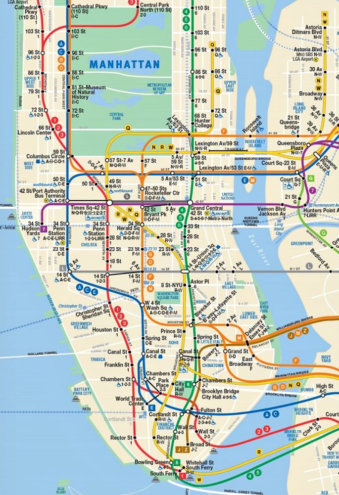
NYC Transit Map, NYC Transit, NYC Subway, MTA, Anthony Denaro, MetroCard, Subway Map, NYC bus, maps
The Manhattan transit system.

Which led, of course, to more questions: “Why aren’t local buses, crosstown buses and the new fancy SBS buses shown? Could the whole bus system fit over a subway map, especially in the areas that aren’t served by the subway?”

This led to the question of why subway ridership has surged while bus ridership has dropped: Are people so confused by the bus system that they just ignore it? Is it seen as an unreliable option? Are people who live outside of subway territory aware of all the bus options at their disposal? Thus began the long, slow journey to fit the whole system of buses and subways on one map.

NYC Transit Map, NYC Transit, NYC Subway, MTA, Anthony Denaro, MetroCard, Subway Map, NYC bus, maps
The Queens transit system.

NYC Transit Map, NYC Transit, NYC Subway, MTA, Anthony Denaro, MetroCard, Subway Map, NYC bus, maps
The Bronx transit system.

The resulting maps follow a few simple guidelines. Make it simple. The riding public needs to know most of the turns and most of the streets as well as relative distance relationships between lines and stations. But not too simple. The focus is on subway lines, streets with buses, arterials and secondary streets, as well as major expressways, rivers and big parks. Stay in bounds. Include only services that can be paid via unlimited MetroCard or offer a free transfer with a pay-per-ride MetroCard. This includes the subway, all NYC Transit and MTA Bus lines, NICE Bus (Long Island) and Bee-Line Bus (Westchester). (Some might take issue with the fact that PATH, LIRR, MNR, Express Buses and EDC Ferries aren’t included.)

The main design directive was to create one graphic system that works for both the subways and buses while remaining true to existing NYCT standards for route bullets, typesetting and language. Everything is displayed at one scale, together, using station names and neighborhoods to denote a terminal.

NYC Transit Map, NYC Transit, NYC Subway, MTA, Anthony Denaro, MetroCard, Subway Map, NYC bus, maps
The Brooklyn transit system.

NYC Transit Map, NYC Transit, NYC Subway, MTA, Anthony Denaro, MetroCard, Subway Map, NYC bus, maps
Brooklyn transit system, detail.

NYC Transit Map, NYC Transit, NYC Subway, MTA, Anthony Denaro, MetroCard, Subway Map, NYC bus, maps
Brooklyn, Coney Island area detail.

As might be expected, Brooklyn proved the most challenging due to the borough’s many unique conditions–one way streets, areas where several bus lines share a street, junctions where six different street grids meet, for example. Says the map’s author: “Six street grids compose the Brooklyn street network. Then these grids needs to connect to Western Queens and Southern Queens. The subway lines then need to relate to Manhattan. Brooklyn’s street layout requires the need for a incremental angle grid. The magic angle turned out to be 22.5/45/90 degrees. 22.5 is the magic number that made this project work. It afforded the right subsect of minor angled lines at 22.5/67.5/112.5 degrees. This kept the map looking neat enough.”

As far as the actual task of getting people to ride the bus more and making the system more efficient and desirable, Denaro hands the task over to the city, the MTA and New Yorkers themselves. “New York, here’s your subway and bus system together in one map, for the first time. Step lively to the surface and the ride the bus, NY.” You can investigate Denaro’s maps further here.

RELATED:

NYC Transit Map, NYC Transit, NYC Subway, MTA, Anthony Denaro, MetroCard, Subway Map, NYC bus, maps NYC Transit Map, NYC Transit, NYC Subway, MTA, Anthony Denaro, MetroCard, Subway Map, NYC bus, maps NYC Transit Map, NYC Transit, NYC Subway, MTA, Anthony Denaro, MetroCard, Subway Map, NYC bus, maps NYC Transit Map, NYC Transit, NYC Subway, MTA, Anthony Denaro, MetroCard, Subway Map, NYC bus, maps NYC Transit Map, NYC Transit, NYC Subway, MTA, Anthony Denaro, MetroCard, Subway Map, NYC bus, maps NYC Transit Map, NYC Transit, NYC Subway, MTA, Anthony Denaro, MetroCard, Subway Map, NYC bus, maps NYC Transit Map, NYC Transit, NYC Subway, MTA, Anthony Denaro, MetroCard, Subway Map, NYC bus, maps

VIDEO: The MTA Tells All About Dumping Its Subway Cars in the Atlantic Ocean

$
0
0
MTA-subway-cars-reefs

6sqft first learned about the MTA’s interesting history of dumping old subway cars into the Atlantic Ocean through Stephen Mallon’s insane photo series. The initiative began in late 2000 as a way to create artificial reefs and revive marine life along the Eastern seabed. Today, 2,400 cars now rest on the ocean floor in six states from New Jersey to Georgia, and we even got a peek inside them thanks to footage from novice divers at Express Water Sports, who lead scuba tours of the Bill Perry Reef system in Myrtle Beach, SC. Now, a video from the MTA itself (h/t Tracks) explains the history of the program, its financial viability, the environmental measures involved in the process, and some concerns about the reefs in the future.

By the early 2000s, the MTA had begun phasing out its Redbird subway cars, which were built between 1959 and 1963. As Michael Zacchea, director of the MTA Artificial Reef Program, explains, they were made with asbestos, presenting a disposal problem. New laws dictated that they couldn’t simply scrap them as they had previously, and so they arrived at the reef idea. By doing this, instead of disassembling them and selling the parts and thereby needing to remove the asbestos, the agency saved $12 million.

Stephen Mallon, NYC subway cars, Next Stop Atlantic
Image by Stephen Mallon. More from his series can be seen here >>

The amount of asbestos in the cars was minimal enough that it wouldn’t affect marine life or human divers, and the MTA removed all other oils and chemicals, along with glass doors, posters, and seats. And so in 2001, 619 51-foot-long Redbirds were dumped 16 miles off the Delaware shore in what is now called Redbird Reef.

NYC subway cars, subway car reefs, artificial reefs, subways being dumped in the ocean, nyc subway car reefs
Image via Express Water Sports

Some environmentalists who are skeptical of the program say it’s unclear whether the cars increase the fish population or just attract them to one place. Another concern is that the cars are collapsing sooner than expected. But as Tracks notes, the sandy, muddy ocean floors of the Mid-Atlantic states typically offers “very little in the way of suitable habitats for the sea life,” which is why the reefs are so important. As 6sqft previously explained, “marine organisms attach themselves to hard surfaces–like the metal frames of the train cars–serving as food for other sea creatures and creating an overall healthier habitat.” Plus, they attract more fishers and diver, boosting the local economy. An Untapped article noted that in 2008, Delaware’s reef was visited by 10,000 anglers, a 3,200 percent increase from 1997. Though the MTA dumped its last batch of cars in 2010, it will surely be interesting to see how the reefs fare in the future.

RELATED:

Video: Take a Gritty Summertime Subway Ride to Coney Island–in 1987

$
0
0
Coney Island Subway 1987, Video, NYC 1987, NYC 1980s, 1987, Nelson Sullivan, Liz Lizard, Michael Musto, Albert Crudo, '80s New York, NYC Subway, Graffiti, Flashback, Vintage Video
one moment please...
Coney Island, NY, United States

From the archives of ’80s NYC nightlife videographer Nelson Sullivan comes this summertime classic video. Young Village Voice writer Michael Musto, artist Albert Crudo, and photographer Liz Lizard with her two kids in tow join Sullivan on the trip to Coney Island from Manhattan on a very different subway than we’re used to today (h/t acapuck via Reddit). Their destination, too, won’t look the least bit familiar to anyone who’s visited the aforementioned beach destination in recent years, though there are many among us who fondly remember the beautiful decay of the boardwalk environs and the thrill of its garish attractions in the pre-MCU, pre Keyspan days.

We never tire of checking out the graffiti-covered cars and fellow riders who probably only look more menacing. And at some moments if you don’t look too hard, everything appears pretty much the same: The noise, the heat, the underground grit–and the fact that when it comes to fashion, everything a few decades old looks cool and new again.

As the long-gone streetscape passes by, the marquee at the also-long-gone Loew’s Oriental (it’s now a Marshall’s) advertises “Beverly Hills Cop II” and “The Untouchables” in a snapshot from a moment in culture. Another difference from today’s F train crowd: No cell phones, of course. “But how did they shoot the video?” you may ask. That, young one, is a story for another day.

RELATED:


This 1927 city subway map shows early transit plans

$
0
0
1927 subway map, Independent Subway System, ISS, IND, transit maps, nyc subway, historic subway maps, city planning, maps

If you’re navigating the NYC subway and wishing you could start from scratch, these map outlines from 1927 might prove interesting. Found by hyperreal cartography, the maps, from the state’s Transit Commission Office of Chief Engineer, outline the “plan of existing and proposed rapid transit lines” for New York City. What’s shown on the map appears to be the Independent Subway System; the ISS or IND, as it was known, was first constructed in 1932 as the Eight Avenue Line.

As one of the three networks that was integrated into the modern New York City subway, the IND was meant to be fully owned and operated by the city government, as opposed to the privately-funded Interborough Rapid Transit Company (IRT) and Brooklyn–Manhattan Transit Corporation (BMT) companies. The three lines merged in 1940.

1927 subway map, Independent Subway System, ISS, IND, transit maps, nyc subway, historic subway maps, city planning, maps

The maps show the first section of this line (the A/C/E trains), with the 6th Avenue Subway, Queens Blvd Subway, Concourse Subway, Crosstown Subway, South Brooklyn Subway and Fulton Street Subway shown as “Projected.”

1927 subway map, Independent Subway System, ISS, IND, transit maps, nyc subway, historic subway maps, city planning, maps

The map shows alternative routes for the Brooklyn and Queens lines, showing a plan to have the express and local tracks split along 69th Street. Apparently this may have had something to do with the proposed Windfield Spur, a local branch of the Queens Blvd Line that would have meandered through Maspeth and Middle Village before heading to Rockaway Park.

1927 subway map, Independent Subway System, ISS, IND, transit maps, nyc subway, historic subway maps, city planning, maps

The F/G trains were originally supposed to run a straight shot from 7th Ave in Park Slope to Prospect Ave in Windsor Terrace, which would have tunneled under Prospect Park and private property until it reached Prospect Avenue. The IND planners added a station at 15th St-Prospect Park; the local track split off the express tracks made this direct path under the park a less-used alternative.

1927 subway map, Independent Subway System, ISS, IND, transit maps, nyc subway, historic subway maps, city planning, maps

The cross-Brooklyn G train looks to be a work in progress here, as if planners hadn’t yet found an ideal route south of Broadway. The Concourse Line (B/D trains) terminates at Bedford Park Boulevard as the trains currently do. Plans for the Brooklyn leg of the Fulton Street Line (A/C) stop at Broadway Junction, which would seem to indicate that planners had not yet completely figured out a suitable route beyond that station.

Back then as now, planners were constantly tinkering with the subway; it would turn out that what they were building would be only the first phase of a much grander of a two-phase plan; what is now remembered as the Second System would see proposed new lines like the 2nd Avenue Subway and Utica Avenue Subway.

RELATED:

1927 subway map, Independent Subway System, ISS, IND, transit maps, nyc subway, historic subway maps, city planning, maps 1927 subway map, Independent Subway System, ISS, IND, transit maps, nyc subway, historic subway maps, city planning, maps 1927 subway map, Independent Subway System, ISS, IND, transit maps, nyc subway, historic subway maps, city planning, maps 1927 subway map, Independent Subway System, ISS, IND, transit maps, nyc subway, historic subway maps, city planning, maps 1927 subway map, Independent Subway System, ISS, IND, transit maps, nyc subway, historic subway maps, city planning, maps 1927 subway map, Independent Subway System, ISS, IND, transit maps, nyc subway, historic subway maps, city planning, maps 1927 subway map, Independent Subway System, ISS, IND, transit maps, nyc subway, historic subway maps, city planning, maps

Subway Reads offers free e-books based on the length of your commute

$
0
0
e-reader on subway, NYC subway

It can be a bit frustrating to start getting into a book on your commute when you just as soon have to put it down, which is part of the idea behind a new initiative called Subway Reads, a web platform that offers free e-books to subway riders that can be timed to their commute.

The program is a collaboration among the MTA, Transit Wireless (the company behind the $250 million+ project to put Wi-Fi in 278 underground stations), and Penguin Random House. According to the Times, the platform was launched as a way to promote the fact that connectivity has already reached 175 stations, but it will only last eight weeks. During that time, users can download novellas, short stories or parts of complete books to their cellphones or tablets, and they can make their selections based on how long they expect to be on the train (the formula accounts for about a page a minute).

Subway Reads
Screenshot from the Subway Reads site

Last year, as 6sqft reported, the Beijing subway introduced a permanent digital library that lets commuters download free e-books by simply scanning QR codes inside train cars. Dubbed “M Subway Library,” the National Library of China chooses 10 new titles every two months from more than 70,000 titles. Also last year, the London Underground ran a similar program to mark Penguin’s 80th anniversary, which is how transit officials got the idea to team up with the imprint in NYC.

As the Times explains:

Subway Reads is offering five novellas or short stories, what Penguin Random House calls e-shorts. Three are by contemporary writers: “High Heat” by Lee Child, “3 Truths and a Lie” by Lisa Gardner, and “At the Reunion Buffet” by Alexander McCall Smith. Two are classics: “The Diamond as Big as the Ritz” by F. Scott Fitzgerald and “The Murders in the Rue Morgue” by Edgar Allan Poe. There are also dozens of excerpts from books, fiction and nonfiction.

In addition to touting the progress made on wiring subway platforms (originally the project was to be completed by 2018, but Governor Cuomo fast-tracked it, and the 98 remaining stations that are in Brooklyn will be connected by the end of the year), Subway Reads will hopefully get other book publishers thinking creatively about digital readers and mass transit.

[Via NYT]

RELATED:

Lead image via Jens Schott Knudsen/Flickr

Video: The first of 300 new R179 subway cars has (finally) arrived at the MTA’s 207th Street yard

$
0
0
R179-subway-cars

The future has arrived, and it’s delayed, of course. The first of the city’s shiny new subway cars was delivered to the MTA yard at 207th street in Inwood last night. The new R179 cars are being made upstate by Canadian company Bombardier and are slated to replace old cars on the C, A, J, M and Z lines (the trains on the C line are the oldest); a final decision on which lines will get the new cars hasn’t been made at this time. The newly-arrived car is a test model, though; we won’t be packing into the new cars like sardines until at least 2018.

300 of the R179s are on order, with more test cars expected to arrive in the next few days. The cars are 60 feet long and though they won’t look too different from the current newer R160 cars that run on the E, F, N, Q lines, they’ll reportedly be fitted with cameras and they’re far more advanced mechanically and electronically.

Second Ave. Sagas tells us that Bombardier was supposed to deliver the test cars last year with the remainder to arrive by 2017. The two-year delay, with new cars scheduled to arrive in 2018 and the old clunkers remaining in circulation until 2022–is reportedly costing the MTA at least $50 million.

So what’s the hold-up? Sources have said that a “welding issue” is partly responsible for the costly delays, and the company, who supplies cars to several other city transit systems, is going through some “economic turbulence.” The Canadian company was the low bidder for the new cars, but the costs of maintenance on the current aging fleet due to the delivery delays has “completely wiped away” any cost savings.

new mta subway designs 2016 6

new mta subway designs 2016 5
Renderings of Governor Cuomo’s proposed new subway cars.

As 6sqft reported, Governor Cuomo recently unveiled plans to build 1,025 new subway cars and to modernize dozens of the city’s more subway stations. The planned new fleet–which does not include the R179 cars–will have an open-gangway format, wider doors, Wi-fi, USB ports, better lighting, cell service, security cameras, full color digital information displays, and a blue and gold color palette to rep New York’s official state colors. As part of a $27 billion capital plan that was approved in May, the new cars are intended to help alleviate overcrowding and reduce delays. Which is somewhat ironic, since replacement of the city’s subway cars has been plagued with perpetual delays; as the old cars roll on, repairs costs pile up, and the cycle repeats itself.

[Via Reddit; Via Second Ave. Sagas]

RELATED:

Uniqlo’s NYC subway-inspired t-shirt collection hits stores

$
0
0
uniqlo subway shirts

The New York City subway map is an icon of our modern urban culture, and it was only a matter of time before the popular graphics made their way on to a t-shirt in some trendy way. Uniqlo just released a new line of SPRZ NY tees featuring designs pulled from the The New York City Transit Authority Graphics Standards Manual, a graphic system designed by Massimo Vignelli and Bob Noorda in the late 1970s. The new line of tees were produced in collaboration with the MoMA and appropriately named, “The Subway and the City.”

Massimo Vignelli, subway-tshirt, MTA, Uniqlo

The t-shirt series includes six designs, each adorned with a different component of the Graphics Standard Manual ranging from the colored circles that identify each subway line to the controversial 1972 version of Vignelli’s famed subway map.

Massimo Vignelli, subway-tshirt, MTA, Uniqlo

Massimo Vignelli, subway-tshirt, MTA, Uniqlo

Each tee-shirt is being sold for an affordable $14.90 on the Uniqlo website.

[Via Curbed]

RELATED:

Massimo Vignelli, subway-tshirt, MTA, Uniqlo Massimo Vignelli, subway-tshirt, MTA, Uniqlo Massimo Vignelli, subway-tshirt, MTA, Uniqlo Massimo Vignelli, subway-tshirt, MTA, Uniqlo Massimo Vignelli, subway-tshirt, MTA, Uniqlo Massimo Vignelli, subway-tshirt, MTA, Uniqlo

MTA kicks off an intensive two-week subway cleanup

$
0
0
W train, mta service changes, second avenue subway, q train

The rats won’t like this.

The MTA’s Operation Track Sweep to spiffy up New York’s subways commenced Monday and will continue for two weeks. More than 500 MTA workers are part of the intensive system-wide cleanup to remove trash and debris from the tracks at all of New York City’s 469 stations— or 10 miles of subway station track.

READ MORE AT METRO NEW YORK…

W train service starts up again November 7th

$
0
0
w-train

NY1 has learned that the W train will make its triumphant return on Monday, November 7th. The line was taken out of service in 2010, along with the V train, due to MTA budget cuts, but the idea to revive the line came about last summer as a way to better connect Astoria when the Q train is rerouted once the Second Avenue Subway opens. As Curbed notes, at first it will operate between 57th Street and Whitehall Street in Lower Manhattan, but will eventually extend to Astoria-Ditmars Boulevard.

MTA-subway map-May 2016-2The MTA’s future subway map showing phase one of the Second Avenue Subway and the reinstated W line

The MTA approved restored W train service at their May board meeting, despite the fact that taking it and the V out of commission saved them $3.4 million a year. As 6sqft previously reported, reviving the line should be relatively simple, as the stations are still in use for the N, Q, and R trains. The announcement also coincides with final testing of the Second Avenue Subway, as phase one–the 72nd, 86th and 96th Street stations–is expected to open by the end of the year.

[Via NY1]

RELATED:

NYC Transit paid $431M in settlements to people injured by trains or buses in last five years

$
0
0
brooklyn_williamsburg_bedford_mta_joe_buglewicz

We’re frequently reminded of the MTA’s efforts to tighten security and keep us safe from terrorists; now the Daily News reports that errors in safety procedures have led to an alarming number of accidental injuries over the past several years. And victims are definitely saying something–at an average of $86.2 million in settlement payments per year, totaling $431 million over the last five years.

NYC subway commute

According to a NYC Transit report, the MTA has failed to fix “hazards on subway platforms citywide,” despite warnings and accidents like one in 2009 which a 19-year-old pre-med student lost part of both legs and injured a hand after falling onto the tracks due to an improperly painted subway platform. A study that took place several months prior to that incident had concluded that “major trip-and-fall dangers” existed at 23 of 27 stations reviewed. That case was settled by the MTA for $9 million last year–for a catastrophe that, according to the victim’s lawyer, “could have been avoided with a simple repair.”

4,592 such cases were settled or adjudicated by the agency for a total of $431 million over the past five years, according to records, including 88 lawsuits yielding payouts of at least $1 million. What’s more, individual cases aren’t reported and no review system exists to point out areas that have led to multiple legal payouts.

While the MTA is fighting lawsuits, cases may drag, and the agency has an incentive to keep the clock running. The state’s Public Authorities law allows NYC Transit to pay a three percent interest rate on any judgement issued while an appeal is pending–other litigants and agencies must pay nine percent while a judgement is pending. Delays can force injured plaintiffs to pay for medical treatment out of their own pockets while their cases play out in court and trial dates roll on into the future with no end in sight. In 2015 the MTA prevailed in 40 of 65 cases.

Transit officials claim they’re protecting the public interest by keeping costs down. But lengthy court cases may mean significantly larger settlements. According to Richard Gurfein, an attorney who won a $7.6 million award in 2013 for someone run over by a city bus 11 years prior, early settlements often save money and lengthy court cases cost taxpayers more. Records show that the amount paid out for lawsuits dropped by 13.2 percent last year–from $99.8 million in 2014 to $86.6 million in 2015.

[Via NYDN]

RELATED:

Second Avenue Subway may miss December opening date

$
0
0
Second Avenue Subway-August 2016

After 100 years of chatter surrounding a Second Avenue Subway, it’s no surprise that the MTA can’t seem to stop flip-flopping on whether or not the line will meet its December opening date. In April of 2015, the agency announced that Phase I was 82 percent complete and on schedule, but this past June, reports of construction snafus signaled what many felt was an inevitable delay. NBC New York now confirms that the MTA is reassessing its timeline due to issues with elevator and escalator testing at the 72nd Street station.

Second Avenue Subway-August 2016-2

These checks won’t be attempted until the end of November, meaning any “glitch” could set the entire project behind, unless the 72nd Street opens later, and the 63rd, 86th, and 96th Street stations open on time. But a briefing book released by the MTA shows that at 86th Street, “progress on station mechanical/electrical equipment and on elevators and escalators needs to improve to assure completion in December.” There are also delays with fire safety tests that were supposed to have already occurred, but won’t until September 30th. The MTA is not publicly citing a delay, but federal official say it could take until February 2018.

[Via NBC]

RELATED:

August 2016 construction shots via MTA/Facebook


VIDEO: MTA runs first test trains on Second Avenue Subway line!

$
0
0
second avenue subway, lexington avenue, 63rd street, train tests, mta, subwayWhile it’s still unclear whether or not the Second Avenue Subway will meet its December opening date, it does look like the rails themselves are just about ready to take on riders. Over the weekend, Youtube user Dj Hammers spotted the agency running trains past the line’s Lexington Avenue-63rd Street station (where a public area has already opened), testing out the third rail, signals and track. Please stand clear of the closing door..lol 5,000 lbs of plates in front of door. Power stress test of our electrical system. Holding out real good so far.. 🙂 A photo posted by Jimmy (@jonsmaxima) on Oct 9, 2016 at […]

‘City of Women’ turns the subway map into an homage to the city’s greatest females

$
0
0
city-of-women-leadModern cities are filled with signs that mark history, and that history often bears men’s names. In New York City, for example, we have Astor Place, Washington Square, Lincoln Center, Columbus Circle, Rockefeller Center, and Bryant Park, just to name a few. In introducing a new book that addresses this status quo, The New Yorker points out that history-making women, on the other hand, “are anonymous people who changed fathers’ names for husbands’ as they married, who lived in private and were comparatively forgot­ten, with few exceptions,” and that their names are notably missing from our streets. In their forthcoming book “Nonstop Metropolis: A New York […]

Second Avenue Subway will open in December without delay, officials say

$
0
0
second-avenue-subway-72nd-streetMTA Chairman Thomas Prendergast is hoping to squash rumors that the Second Avenue Subway (SAS) will miss its December opening date. As Prendergast told the Times on Friday, “[we want to show riders] we live up to our promises” and that they are “now within striking distance of having it done.” The chairman’s remarks incidentally coincide with some newly unearthed information from the Daily News, who also reported Friday that the agency spent a week shaving down parts of the new subway tunnel wall because 75-foot train cars couldn’t fully clear curves. The MTA running test trains earlier this month The tunnel issue, however, is much lower on the agency’s list of concerns (as the […]

MTA puts up flyers touting the W train’s November 7th return

$
0
0
mta-w-train-poster6sqft revealed last month that the W train would be making its triumphant return on Monday, November 7th, restoring service from Astoria to Lower Manhattan. Now that the date is only a couple weeks away, the MTA is putting up flyers touting the new re-instated line, reports Pix 11. Designed to look like a flashy Broadway marquee, the poster was spotted by a Reddit user over the weekend at the 34th Street-Penn Station platform of the A,C,E train. As 6sqft previously explained, “The line was taken out of service in 2010, along with the V train, due to MTA budget cuts, but the […]

Independent engineer says two Second Avenue Subway stations are still far from ready

$
0
0
Second Avenue Subway-August 2016Despite MTA Chairman Tom Prendergast’s seemingly unwavering optimism that the Second Avenue Subway will open on time, it’s still not clear if the line’s stations will be ready for their December ribbon cutting. According to the Times, following a Wednesday MTA board presentation outlining some of the outstanding issues (and the agency’s commitment to smoothing them out over the next eight weeks), Kent Haggas, an independent engineer for the project, offered up a very somber outlook. As he told the paper, two of the three stations set to open December 31st have fallen behind, and that the system’s “rigorous testing schedule was not being met.” More alarmingly, […]
Viewing all 390 articles
Browse latest View live